CCEMA: Rain increasing ahead of cold front
Published 5:48 pm Monday, March 1, 2021
|
Getting your Trinity Audio player ready...
|
Rain showers will increase in coverage across the region along and ahead of a cold front that will be pushing across the area. The front will stall over the Gulf tonight, but a series of upper level systems will spread across our forecast area late tonight through Tuesday evening, according to the Covington County Emergency Management Agency.
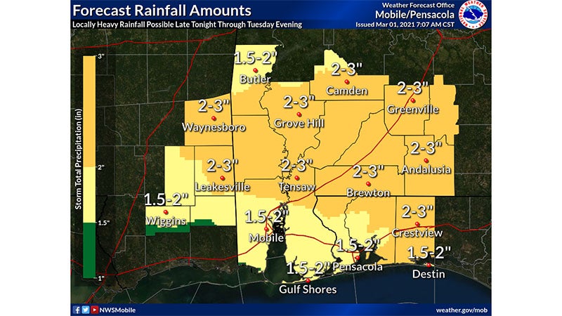
Rain showers will become widespread in coverage after midnight tonight and will continue through the day Tuesday. A few thunderstorms will also be possible through Tuesday evening. Periods of heavy rainfall will be possible late tonight through Tuesday evening, which could lead to minor flooding of low lying and urban areas. “We will also be watching for what is currently a very low potential of an isolated strong to severe storm near the immediate coast from Gulf Shores to Destin late Tuesday afternoon into Tuesday evening as the front over the Gulf retreats northward to near the coast during this time,” said CCEMA Director Susan Harris.
Where and When:
- Widespread rain showers and a few thunderstorms will develop across the area after midnight tonight and will persist through the day Tuesday, before tapering off from west to east Tuesday evening.
- Rainfall amounts between 1.5″ and 3″ with localized higher amounts will be possible during this time. Localized flooding is possible, mainly in urban and poor drainage areas.
- While any severe threat will probably remain confined to the coastal Gulf waters Tuesday evening, we will be monitoring the immediate coast from Gulf Shores to Destin for the possibility of an isolated strong to severe storm capable of damaging winds or a tornado if the warm front can make it as far north as the coast. The time frame of interest for this very limited possibility currently looks to be from about 6 PM – midnight Tuesday evening.
More News


-
Polls
 Loading ...
-
-